After leaving Jalama Beach we drove north to CA 166 and then east to the Cuyama Valley.

Entering the Carrizo Plain National Monument.

Entering the Carrizo Plain National Monument.
The start the Caliente Ridge Road. I have driven this road four times and what the sign doesn't tell the driver is that the road is narrow with few turnouts and not a place you want to be when it rains.
Dawn on Caliente Ridge. It was windy but not very cold (40º) during the night. This is where I began my bike and hike to Caliente Mountain.
My shadow accompanies me as I ride the old dirt road.
The radio tower is the first way-point on the trail.
This picnic table is the second way-point on the trail.
The road deteriorates past this old gate but is still an easy ride.
I parked my bike near this guzzler, third way-point, and began to hike.
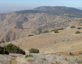
A view of Caliente Mountain from the last of several false summits.
Fog covers the lowlands to the southeast.
A raptor searching for lunch.
Rock formation near the summit.
I reach the summit of Caliente Mountain, after 8 miles of biking and hiking up and down the ridge-line. (Did I mention up and down the ridge-line?) The WWII observation cabin has now collapsed. Photo from 1989.
Found this entry in the summit register concerning lost pilot Christopher Kidd.
To the southwest the Sierra Madre rise above of the fog.
After leaving the summit I hike back to my bike. Camp is three miles beyond the high ridge in the distance. I am looking forward to making it to the tower on that ridge because from there it is 80% down hill.
While back at camp changing my shoes two riders came by and asked if we could provide some water for their dog. After "Fido" hydrated they headed back to Selby Camp.
Exiting the Caliente Ridge Road.
Looking back.


