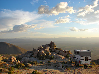
We made camp at an elevation of 4300 feet about 1200 feet above Indian Wells Valley. At the time we made camp winds were moderate. The exposed location with the camper rocking in the wind made Jan concerned which made me concerned. I guyed the camper down to a boulder. Later that evening NOAA Weather Radio on 2 meters gave a high wind warning for our area predicting winds between 35-45 MPH with gusts over 60 MPH. I rigged a second guy to another boulder. The entire night winds smashed (what it felt like) against the camper, rocking and shaking our little world.
Dawn after a very breezy night. It was the windiest night ever spent in the camper. Outside at 2 AM, with sand goggles on, checking the guy lines, a gust hit me and sent me stumbling into the camper. Around 3 AM a massive gust slammed into us and I commented out loud that it 'was getting a little breezy' and Jan remarked, "no shit, Sherlock." Considering that Jan never uses impolite language the reader can judge the severity of the winds that night. (The NOAA Indian Wells Canyon station recorded gusts over 50 MPH, Five Mile Canyon recorded a gust of 68 MPH)
While drinking our morning tea a couple of 4X4 vehicles from SAR China Lake NAWS arrived and we were told that a training exercise was about to begin.
Twenty minutes later a helicopter roared over our camp. This video is a short compilation of the 90 minute training session. I have seen helicopters in use before but never with wind conditions like they were on this day.
Departing our camp site.
Wild flowers were beginning to bloom.
We drove further up the canyon to explore.
Then we drove to Ridgecrest for some medical attention.
Thought that we would spend hours at the hospital but were in and out in just 90 minutes.
Drove north on US 395 to Big Pine and then west to Glacier Lodge. The X-Country skiing was better than expected.
The trout pond at Glacier Lodge and somewhere back in the clouds would be Norman Clyde Peak.
Jan spotted these snow covered rocks and remarked that they looked like frosted cupcakes.
Bobcat tracks found on our way to the North Fork bridge. Tried to sell Jan on the idea that they were mountain lion tracks but she wasn't buying.
The icy cold waters of the North Fork of Big Pine Creek.
An icy falls 'frozen' in motion.
South Fork of Big Pine Creek
Ice on branches forms inverted crystal goblets.
Closer look.
Jan's route to the restroom.
Driving back down to warmer temperatures
and noticed a couple of deer near the road. Looked closer and saw this large herd. We sighted a larger herd about 1/2 mile down the road.
It had been more than 20 years since I had stopped and paid my respects.
The mass grave site.
Jan spotted Gorilla Rock on the road to McCloud Flat.
Sunset was approaching as we passed this small cabin near the McCloud Mine.
Dawn on McCloud Flat.
An hour after dawn.
Why we love the desert.
View to the south of our camp.
The only snow remaining on McCloud Flat.
McCloud Flat and our Four Wheel Camper from a NE ridge mine site.
Olancha Peak, 12,132 feet, still hidden behind clouds.
Descending from McCloud Flat.
Approaching Cactus Flat. US 395 is about 10 miles away and then we turn left and head for home.


