Use the archive on the right to view older posts.

Monday, February 20, 2017

Return to the Turtle Mountains - "a screeching bush"

We reached the Turtle Mountains late in the afternoon.
In the distance shadows were moving toward the collapsed remains of the Lost Arch Inn as we drove to our objective.
Several years before I had noticed a grave marked on a topo map 1/2 mile from the Inn and decided to investigate on this trip. We found a mound of rocks about six feet long but no marker.
We drove into the sunset on the way to our campsite.
Evening in the Turtle Mountains.
Dawn.
After a late breakfast we hiked an old road into wilderness.
Soon there was evidence that the area had been trammeled by man.
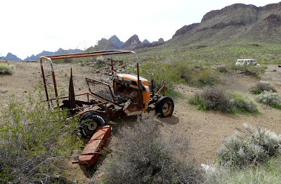
We found several vehicles. This was the most interesting.
Cabin foundation.
A path led to the outhouse which was intact although reclined.
Curious machine. Maybe a home-brew dry washer.
After giving much thought to the history and forgotten stories of the old camp we hiked cross-country back to the truck.
We ate a late lunch serenaded by a screeching bush that had somehow managed to position a broken branch perfectly behind a BLM road sign that was moving with the wind. What kind of serendipity was at play to make this happen?
After lunch we drove about five miles West and reestablished our camp. Sunset was cloudy.
It was a windy morning with a gray sky.
Once again we were hiking on a perfectly good road into wilderness.
Bosco led the way as we began our hike deep into the Turtle Mountains.
We passed by many old claim markers
and unique pieces of
mining history alongside the road.
The road continued South.
Ocotillo were green with new leaves.
View from inside.
Many old campsites were discovered along the road.
And the road continued South.
Then turned East toward Umpah and Mopah.  A view of the Turtle Mountains that few people get to see.
And then South again passing more campsites along the road. This area must have been a wonderful place to explore and camp before the roads were closed by the Desert Protection Act of 1994.
45 minutes later we reached our objective.
This old Packard
marked the destination of our hike.
Herbert Pulver owned a Packard Automobile dealership in Santa Monica in the 1930's.
We found the outline of a cabin with rocks set in cement and several hardened bags of cement.
After lunch and rest it was time to hike back to the truck.
Photograph of a photographer taking a photograph.
Our route took us through several washes as we retraced our tracks.
We reached camp about two hours after sunset.
Dawn.
Later in the morning more than a dozen
helicopters flew over our location headed East.
We left the Turtle Mountains behind.
More helicopters flew East over the desert.
We visited
several old cabins
on our return to I-40.

Sunday, February 12, 2017

North and South of CA 166 - "things were going to deteriorate"

 A mudslide closed the right lane of the northbound Interstate 5.
 After the lane closure it was a clear drive down the Grapevine and into the San Joaquin Valley.
We drove West on CA 166 and found the road closed. I checked the Caltrans website and it had not shown this closure.
 Several sections of the highway were single track through the mud and there was one short section with about 12 inches of water but many locals were driving the road.
 A pastoral scene a few miles East of Maricopa.
 Looking East down Grocer Grade toward Maricopa.
 We turned North on Soda Lake Road and drove onto the Carrizo Plain.
 After the pavement ended road conditions became sloppy and a rain squall in the distance meant things were going to deteriorate.
 Wanting to avoid the quagmire that this road can become when wet we set up camp at the old Morris homestead.
 Sunset arrived an hour later.
 At 10:06 a rabbit visited our camp.
 Dawn was misty and damp.
 Less than a mile to the West of our camp was a small cemetery.
 Bosco and I strolled over to the site.
Another homestead in the southern end of the Plains was established in those years by the family of Edmund and Mary Morris. Mary died in 1896 and lies in a grave plot near the homestead. - santamargaritahistoricalsociety.org
The Mary and Edmund Morris family homesteaded four 1/4 sections of land (160 acres each), totaling to 640 acres of land on the SE end of the Carrizo Plain in 1889. They also purchased an additional 800 acres of land. The Morris' had three children: Tom, Joe, and Emma. - findagrave.com

 The first time I visited this cemetery was in 1988, 29 years ago. I was a young man then. Now I am the same age as Mary when she died. It was wet and muddy that spring as well.
 Bosco and I hiked farther into the hills.
 After an hour we turned around and headed back to camp. This spring may bring a super-bloom after such great rain totals.
 Bosco found an old horse hoof to chew while I read.
 More rain moved into the area and I made the decision to break camp.
 Every time we drive past cattle Bosco whines and wants out of the truck because his instinct is to get out there and take charge.
 Decided to drive up and over the mountains instead of returning home via the 166.
 After 25 miles or so we reached snow.
 We drove up Mount Pinos until we could drive no farther.
 This was Bosco's second time in deep snow and he did not like it any more than the first.
 We would have stayed the night but I had neither skis or snowshoes so as night fell we made for home.